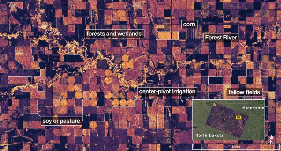
This image provided by NASA/JPL-Caltech on Aug. 23, 2025, NISAR imaged land adjacent to northeastern North Dakota’s Forest River, light-colored wetlands and forests line the river’s banks, while circular and rectangular plots throughout the image appear in shades that indicate the land may be pasture or cropland with corn or soy. (NASA/JPL-Caltech via AP)
In this image provided by NASA/JPL-Caltech captured on Aug. 21, 2025, NISAR’s L-band radar shows Maine’s Mount Desert Island, green indicates forest; magenta represents hard or regular surfaces, like bare ground and buildings. The magenta area on the island’s northeast end is the town of Bar Harbor. (NASA/JPL-Caltech via AP)
First radar images from new Earth-mapping satellite showcase Maine coast and Minnesota farmland
CAPE CANAVERAL, Fla. (AP) — NASA’s first radar images from a new Earth-mapping satellite show the Maine coast and Minnesota farmland in incredible detail.
This image provided by NASA/JPL-Caltech on Aug. 23, 2025, NISAR imaged land adjacent to northeastern North Dakota’s Forest River, light-colored wetlands and forests line the river’s banks, while circular and rectangular plots throughout the image appear in shades that indicate the land may be pasture or cropland with corn or soy. (NASA/JPL-Caltech via AP)
CAPE CANAVERAL, Fla. (AP) — NASA’s first radar images from a new Earth-mapping satellite show the Maine coast and Minnesota farmland in incredible detail.
The pictures, released Thursday, are from a spacecraft that rocketed into two months ago.
The joint U.S.-Indian mission, worth $1.3 billion, will survey virtually all of the world’s land and ice masses multiple times. By tracking even the slightest shifts in land and ice, the satellite will give forecasters and first responders a leg up in dealing with floods, landslides, volcanic eruptions and .
ARTICLE CONTINUES BELOW
NASA said these first pictures are a preview of what’s to come once science operations begin in November.
The satellite, flying 464 miles (747 kilometers) high in a near polar orbit, is called NISAR, short for NASA-ISRO Synthetic Aperture Radar. ISRO is the Indian Space Research Organization.
___
The Associated Press Health and Science Department receives support from the Howard Hughes Medical Institute’s Department of Science Education and the Robert Wood Johnson Foundation. The AP is solely responsible for all content.