
SAN JUAN, Puerto Rico (AP) ŌĆö Not a single named storm has formed in the Atlantic Ocean in nearly three weeks, even though itŌĆÖs the peak of hurricane season.
ŌĆ£Where the heck are the Atlantic #hurricanes?ŌĆØ Philip Klotzbach, a meteorologist at Colorado State University, wrote recently on X.
Many are wondering the same thing.
was the last named storm to form this season. It was short-lived, forming on Aug. 23 and dissipating on Aug. 28 while remaining over open water.
This is only the second time that no named storms have formed during the peak of the Atlantic hurricane season since modern record-keeping began in 1950, according to Ernesto Rodr├Łguez, meteorologist in charge of the National Weather Service forecast office in San Juan, Puerto Rico.
ŌĆ£Usually, conditions during this period are prime,ŌĆØ he said.
The quietest peak running from Aug. 29 to Sept. 15 was recorded in 1992, after devastated Florida.
Why it’s so quiet
Three factors are to blame, or cheer.
One, a strong vertical wind shear, which refers to a change in wind speed or direction with altitude. It has increased thanks to a cyclonic circulation in the mid-upper troposphere, which is the lowest region of the EarthŌĆÖs atmosphere.
Two, persistent dry and stable air across the tropical Atlantic.
And three, a drop in the amount of rainfall in West Africa, where tropical waves form during the hurricane season.
ŌĆ£This is pretty positive, especially for us in Puerto Rico,ŌĆØ Rodr├Łguez said.
The U.S. territory is still rebuilding from , which hit the island as a powerful Category 4 storm on Sept. 20, 2017.
The lack of storms prompted experts at Colorado State University to publish an explanatory report earlier this month.
ŌĆ£There has been considerable discussion amongst meteorologists, the media and the general public about the recent quiet period for Atlantic hurricane activity,ŌĆØ the report stated, which called it ŌĆ£quite remarkable.ŌĆØ
We’re not in the clear
Forecasters say we could still see a busy season in the second half of September and the first part of October.
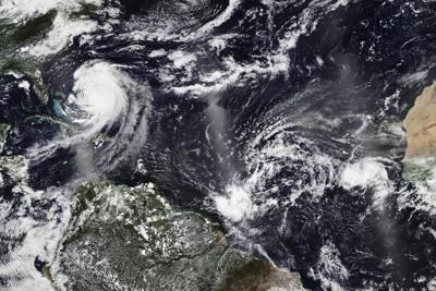
A cluster of storms currently located hundreds of miles east of the Caribbean is forecast to become a named storm in upcoming days, although itŌĆÖs expected to turn away from the region and remain over open water, possibly as a powerful hurricane.
Another cluster of storms is swirling behind it, but so far, it only has a 20% chance of formation.
ŌĆ£From Sept. 15 to Oct. 15, conditions will be pretty prime,ŌĆØ Rodr├Łguez said.
He noted that ocean temperatures remain warm, which provides fuel to storms.
What history says
Up to 80% of hurricane activity in the Atlantic occurs in August and September, but this year has seen only six named storms.
ŌĆ£One of the issues plaguing the Atlantic this hurricane season has been insufficient instability,ŌĆØ according to the report by Colorado State University.
The National Oceanic and Atmospheric Administration had predicted an above-normal season with 13 to 18 named storms. Of those, five to nine were forecast to become hurricanes, including two to five major hurricanes, which pack winds of 111 mph or greater.
Erin strengthened into this yearŌĆÖs first Atlantic hurricane in August, as it bypassed land. No other hurricanes have formed since then.
A typical hurricane season in the Atlantic, which runs from June 1 to Nov. 30, will yield 14 named storms, of which seven strengthen into hurricanes and three become major hurricanes, according to NOAA.
ŌĆ£The conga line of tropical waves exiting Africa that hits its peak by late August and September ŌĆö is a little late to the party this season,ŌĆØ wrote hurricane specialist and storm surge expert Michael Lowry in his most recent report.


